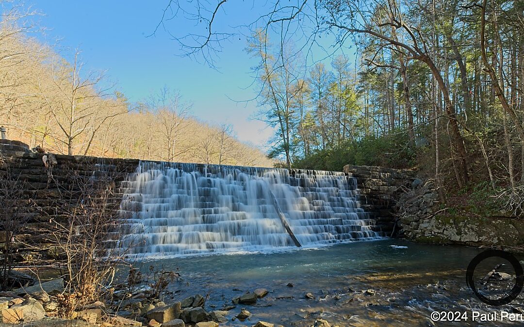
Otter Lake Waterfall is a beautiful natural wonder situated in Western Amherst County, Virginia. It is a peaceful haven that epitomizes the serene beauty of the region. The waterfall is formed due to the low-head dam that holds Otter Lake, which is a popular spot located within the Washington/Jefferson National Forest. The area is a perfect amalgamation of lush greenery and diverse wildlife, making it an ecological paradise.
The cascade of the waterfall, a gentle, stair-stepped flow of water, provides a soothing soundtrack of flowing water that can be heard as visitors approach the waterfall on the path from the parking lot. The area around the waterfall, with its ideal picnic spots and opportunities for photography, invites visitors to immerse themselves in the peaceful ambiance of the forest. The cool mist generated by the falls, especially during the hot summer months, offers a refreshing respite.
Otter Lake Waterfall, a beloved spot among visitors, is not just a scenic wonder but also a habitat for various species of birds and aquatic life. Its accessibility, combined with its scenic setting, makes it a cherished destination for both locals and travelers seeking a quiet escape into nature. The waterfall’s location within the national forest opens up a world of possibilities for hiking, camping, and other outdoor activities, promising an exciting adventure for all.
Otter Lake Waterfall is a serene and picturesque natural retreat that showcases the region’s tranquil beauty. Its accessibility, scenic setting, and abundance of wildlife and greenery make it ideal for anyone seeking a peaceful escape into nature.
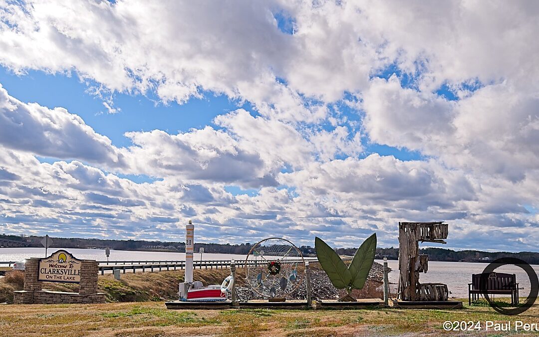
The “Love” sign in Clarksville, Virginia, stands as a vibrant emblem of the town’s warm, welcoming nature and its status as a beloved destination along the Virginia LOVEworks trail. This iconic installation, located conveniently for visitors entering the town, is made up of large, colorful letters that spell out “LOVE,” each letter creatively capturing a unique aspect of Clarksville’s local culture and natural beauty. The L represents lake life, Lakefest, and our the love for our town. The O represents Clarksville’s history of the Occoneechi Indians and the opportunities available in Clarksville. We hope to capture great memories and visitors’ hearts and dreams of visiting again and again (or even that folks will want to live here)! The V is for the many visitors that vacation in Clarksville. We want you to value your time with us! The E is for wishing everyone wonderful experiences, considering Clarksville’s proximity to Kerr Lake, one of the largest freshwater lakes in Virginia. This art piece not only offers a perfect photo opportunity for tourists and residents alike but also serves as a reminder of the town’s commitment to fostering a sense of unity and affection among its community members. Throughout the year, the sign becomes a focal point for various community events, symbolically representing the love and pride that the people of Clarksville hold for their picturesque town.
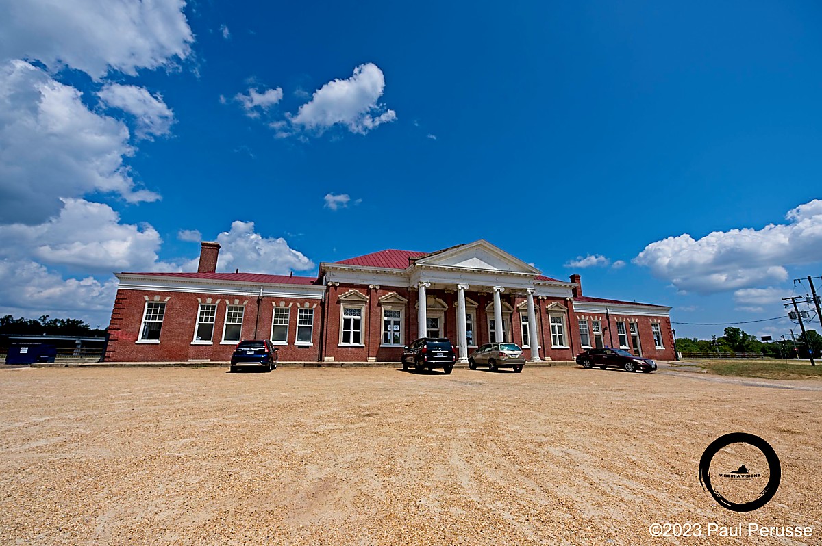
The origins of Union Station in Petersburg, Virginia.
Nestled in the heart of downtown Petersburg, Union Station is a historic landmark that has played a significant role in the city’s past. Replacing the original 1840s Richmond and Petersburg Railroad station, built in 1909, this beautiful building served as a vital transportation hub for seven decades, connecting the bustling city to the rest of the nation.
The Golden Age of Railways
During the late 19th and early 20th centuries, rail travel was at its peak, and Union Station was at the forefront of this transportation revolution. As the largest train station in the area, it welcomed thousands of passengers and played a crucial role in the economic development of Petersburg.
Passengers from all walks of life passed through the station’s grand entrance, creating a vibrant atmosphere and a sense of anticipation. From businessmen to soldiers returning from War, Union Station witnessed countless stories unfold within its walls.
A Witness to History
As time went on, Union Station continued to evolve and adapt to changing transportation needs. It underwent various renovations and expansions, further solidifying its position as a central hub for travelers.
As Amtrak took over passenger rail service in the early 70s, the majority of passenger service was moved a few miles west to the Ettrick station, on the North South Main line.
End of an Era
The last passenger train to pass through the station was the “Hilltopper” on September 30th, 1979. This marked the end of an era for the station, as it had served as a bustling hub for train travel for many years. The Hilltopper was a beloved train that connected various towns and cities, offering a convenient mode of transportation for both commuters and travelers.
During its heyday, the station bustled with activity as passengers hurriedly boarded and disembarked from the trains. The platform was always filled with eager travelers, anxious to reach their destinations or embark on new adventures. Families bid tearful farewells, while others eagerly awaited the arrival of loved ones.
The station itself was a charming building, with its elegant architecture and distinctive design. The grand entrance, with its double doors and intricate detailing, welcomed passengers into a spacious and well-appointed interior.
So, as the Hilltopper made its final journey on that fateful September day in 1979, it marked the end of a chapter in the station’s history. In 1980, the station was added to the National Register of Historic Places, so the memories and stories of the station’s past can continue to live on, reminding us of the once-thriving era of train travel and the important role that this station played in connecting people and communities.
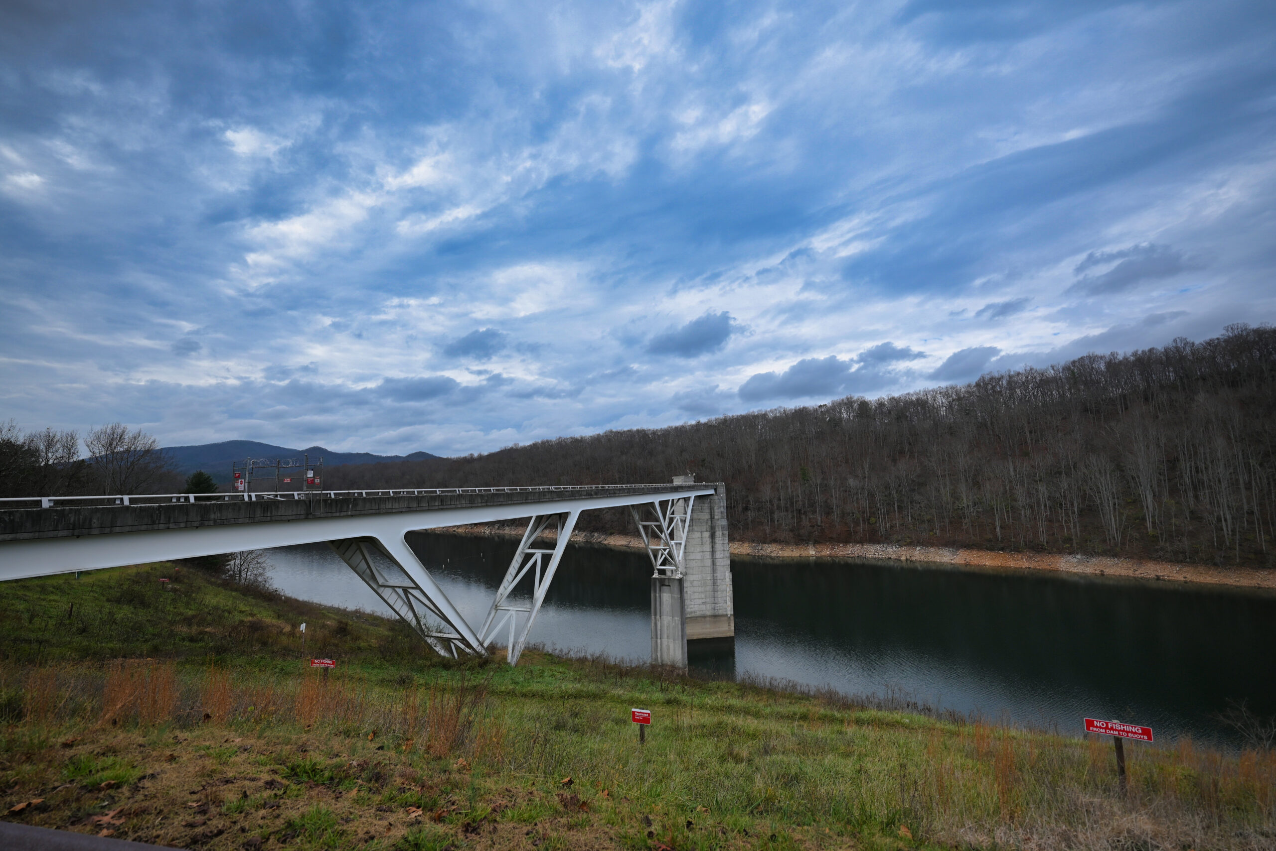
Gathright Dam and subsequently Lake Moomaw, were created by the U.S. Army Corps of Engineers, to control flooding of the Jackson River, and protect the city of Covington. The dam is named after Thomas Gathright, the owner of the majority of the land flooded by the dams’ construction. The lake is named after Benjamin Cline Moomaw, Jr. a Covington businessman who was influential in getting the dam built.
Sorry, there are not many pictures, as we kind of stumbled across the dam, we had other plans, but plans change when you see a sign that says, “Turn here for Lake Moomaw”. There were not many places to get many good views of the lake, and not an easy lake to drive around.
Gathright Dam
The dam’s primary purpose is to control the levels of the Jackson river, and indirectly the James River, protecting thousands of square miles of Virginia, including the cities of Lynchburg and Richmond along the tens of thousands of people.
The Dam is over 1,300 feet (396.24 m) long, and more than 250 feet (76.2 m) tall, the base of the structure is 1,000 feet (304.8 m) wide, and 35 feet (10.67 meters) at the top. The dam impounds between 40 and 130 Billion gallons of water.
The tower pictured below is called the “Intake tower”, which is confusing, since it is used to release water to maintain the downstream flow of the Jackson river. Also pictured below is a staircase, all the way to the bottom, to provide access to various instruments that monitor the dam.
Lake Moomaw
Lake Moomaw’s impoundment is between 30 and 137 Billion gallons of water, it has a surface area of roughly 4 square miles which fluctuates with water level. The lake is normally drawn down 10 to 15 feet over the summer months. The lake is surrounded by 43 miles (69.2 km) of wild shoreline.
Sorry, there are not more pictures, we were unable to make it to the other side of the lake where there are more facilities.
Recreation
The US Forest Service manages the campsites around the lake, there are 140 campsites and 33 RV sites with Electrical hookups. The campsites are closed though the winter months. There are 4 boat ramps around the lake to launch boats up to 25 feet (7.62 m).
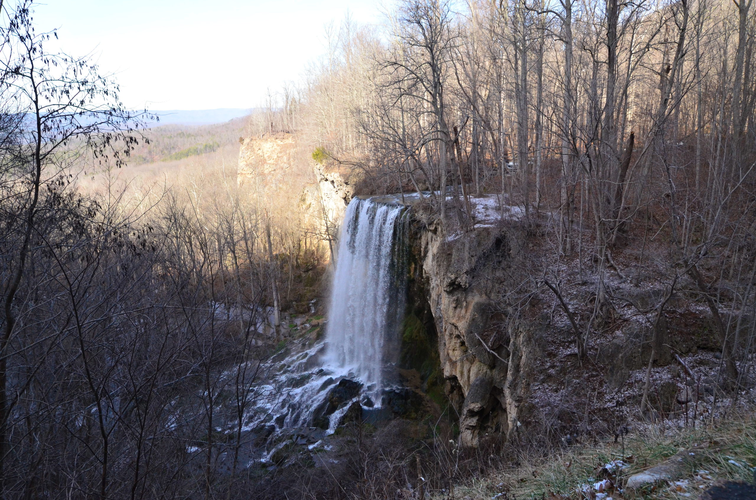
Falling Spring Falls a beautiful sight to see, and I will be fortunate to be visiting again real soon. The falls are located on US-220 in Allegheny County, visiting can be tricky on a busy day as there are a very limited number of parking spots and the highway can be very busy. Look for updates in about 2 weeks.
Falling Spring Falls 25Falling Spring Falls 26Falling Spring Falls 27Falling Spring Falls 28Falling Spring Falls 29Falling Spring Falls 30Falling Spring Falls 31Falling Spring Falls 32Falling Spring Falls 33Falling Spring Falls 34Falling Spring Falls 35Falling Spring Falls 36Falling Spring Falls 37Falling Spring Falls 38
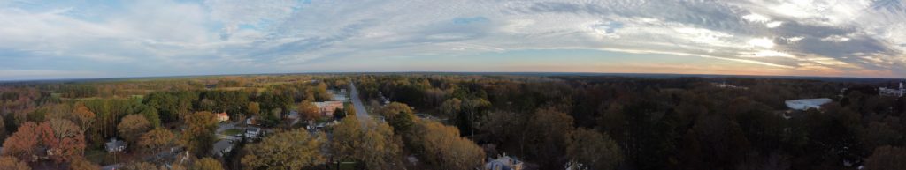
This is Kenbridge, a very small town in southside Virginia.
Looking South Looking To The West
Just over 1,200 people call Kenbridge home, Kenbridge was once one of the largest tobacco markets, in Virginia, and many of the old warehouses still stand, and are in use today..


Recent Comments